Birmingham City Council
Tree preservation zone
There is a problem
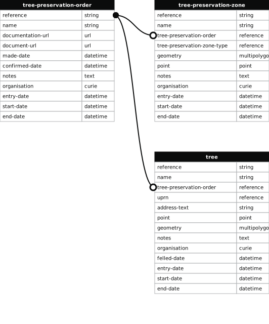
- 1000 entries with tree-preservation-order field must match the reference field in the tree preservation order dataset
THE BIRMINGHAM (LAND ADJOINING WORCS AND B'HAM CANAL AND BOUNDED BY RADDLEBARN RD, UMBERSLADE RD, RIBBLESDALE RD AND OXFORD ST, BOURNVILLE) TPO 1983
- reference
- 411
- name
- THE BIRMINGHAM (LAND ADJOINING WORCS AND B'HAM CANAL AND BOUNDED BY RADDLEBARN RD, UMBERSLADE RD, RIBBLESDALE RD AND OXFORD ST, BOURNVILLE) TPO 1983
- tree-preservation-order
- TPO 411
- tree-preservation-zone-type
- area
- geometry
- MULTIPOLYGON (((-1.929774 52.436492,-1.929894 52.436429,-1.930174 52.436306,-1.930273 52.436270,-1.930250 52.436247,-1.930226 52.436234,-1.930182 52.436216,-1.930123 52.436196,-1.929904 52.435968,-1.929618 52.435631,-1.929606 52.435615,-1.929485 52.435387,-1.929350 52.435111,-1.929316 52.435048,-1.929301 52.435002,-1.929298 52.434988,-1.929296 52.434961,-1.929266 52.434893,-1.929238 52.434863,-1.929233 52.434856,-1.929233 52.434853,-1.929227 52.434847,-1.929206 52.434815,-1.929199 52.434799,-1.929175 52.434715,-1.929164 52.434687,-1.929095 52.434534,-1.929083 52.434512,-1.929057 52.434454,-1.928898 52.434149,-1.928893 52.434132,-1.928893 52.434114,-1.928889 52.434081,-1.928881 52.434068,-1.928693 52.433642,-1.928633 52.433485,-1.928641 52.433481,-1.928618 52.433435,-1.928358 52.432883,-1.928360 52.432879,-1.928384 52.432861,-1.928392 52.432853,-1.928393 52.432839,-1.928390 52.432835,-1.928359 52.432761,-1.928336 52.432747,-1.928308 52.432734,-1.928297 52.432721,-1.928289 52.432720,-1.928280 52.432696,-1.928258 52.432693,-1.928193 52.432541,-1.928177 52.432468,-1.928029 52.432129,-1.928012 52.432073,-1.927988 52.432004,-1.927994 52.431989,-1.927994 52.431972,-1.927893 52.431716,-1.927871 52.431666,-1.927714 52.431226,-1.927672 52.431199,-1.927655 52.431154,-1.927486 52.430686,-1.927414 52.430491,-1.927273 52.430084,-1.927283 52.430024,-1.927230 52.429869,-1.927253 52.429834,-1.927259 52.429818,-1.927259 52.429811,-1.927255 52.429797,-1.927250 52.429790,-1.927208 52.429761,-1.927192 52.429748,-1.927186 52.429739,-1.927066 52.429398,-1.927074 52.429379,-1.927091 52.429353,-1.927096 52.429341,-1.927094 52.429327,-1.927087 52.429317,-1.927080 52.429311,-1.927019 52.429270,-1.926972 52.429134,-1.926505 52.429206,-1.926515 52.429236,-1.926563 52.429342,-1.926631 52.429483,-1.926651 52.429520,-1.926701 52.429601,-1.926566 52.429630,-1.926525 52.429643,-1.926439 52.429681,-1.926383 52.429715,-1.926317 52.429749,-1.926264 52.429773,-1.925855 52.429902,-1.925839 52.429909,-1.925806 52.429932,-1.925793 52.429939,-1.925755 52.429972,-1.925747 52.429984,-1.925703 52.430019,-1.925649 52.430075,-1.925614 52.430114,-1.925586 52.430152,-1.925565 52.430190,-1.925562 52.430202,-1.925541 52.430223,-1.925516 52.430253,-1.925475 52.430280,-1.925440 52.430299,-1.925419 52.430308,-1.925293 52.430344,-1.925198 52.430387,-1.925138 52.430408,-1.925115 52.430414,-1.925088 52.430420,-1.924908 52.430447,-1.924890 52.430459,-1.924879 52.430463,-1.924771 52.430483,-1.924655 52.430498,-1.924569 52.430511,-1.924600 52.430596,-1.924600 52.430610,-1.924606 52.430639,-1.924604 52.430658,-1.924590 52.430681,-1.924556 52.430712,-1.924293 52.430841,-1.924315 52.430855,-1.924868 52.431241,-1.925208 52.431480,-1.925445 52.431647,-1.925611 52.431767,-1.925866 52.431948,-1.926153 52.432149,-1.926418 52.432338,-1.926679 52.432520,-1.926608 52.432562,-1.927381 52.433208,-1.927421 52.433190,-1.927457 52.433177,-1.927544 52.433250,-1.927599 52.433309,-1.927679 52.433386,-1.927727 52.433439,-1.927792 52.433503,-1.927855 52.433561,-1.927983 52.433684,-1.927337 52.433920,-1.927802 52.434396,-1.927865 52.434457,-1.927879 52.434475,-1.928107 52.434709,-1.928844 52.435450,-1.929373 52.435979,-1.929227 52.436067,-1.929492 52.436206,-1.929373 52.436276,-1.929774 52.436492)))
- point
- POINT (-1.927198 52.432229)
- notes
- The shaded area represents those properties which fall within the outline of a Tree Preservation Order. To precisely identify trees protected by the Order, you can request a copy of the tree preservation order at the following link.
- entry-date
- 2026-10-15
- start-date
- end-date
How to fix this issue
Your data is missing a tree-preservation-order.
The tree preservation zone guidance explains how to fix the issue:
tree-preservation-order
The reference for the tree preservation order that covers this zone.
How to improve Birmingham City Council’s data
- Fix the errors indicated
- Use the check service to make sure the data meets the standard
- Publish the updated data on the endpoint URL